Introduction
South Africa, a land of rich biodiversity, diverse cultures, and complex history, is best understood through the lens of maps and facts that encapsulate its geographical features, demographic makeup, and historical evolution. In this comprehensive guide, we will delve into the intricacies of South African maps and present a wealth of facts that offer a holistic understanding of this captivating nation at the southern tip of the African continent.
Geographical Landscape
Topography and Regions
South Africa’s topography is incredibly varied, featuring the iconic Table Mountain in Cape Town, the vast Karoo semi-desert, and the Drakensberg mountain range. Maps will guide you through the diverse regions, showcasing the unique landscapes that define the country.
Coastlines and Oceans
With coastlines along both the Atlantic and Indian Oceans, South Africa’s maritime features are crucial. Maps detailing the ocean currents and coastal geography provide insights into the nation’s strategic position and marine ecosystems.
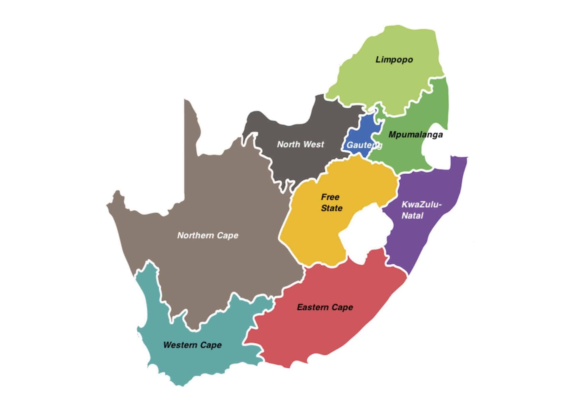
Political Map and Administrative Divisions
Provinces and Capitals
South Africa is divided into nine provinces, each with its own distinctive character. A political map will illustrate the administrative divisions, from Gauteng with Johannesburg as its economic hub to the Western Cape with the legislative capital, Cape Town.
Cities and Urban Centers
Explore the urban landscape through maps highlighting major cities such as Pretoria, Durban, and Port Elizabeth. Each city contributes uniquely to South Africa’s economic, cultural, and historical tapestry.
Cultural Diversity and Demographics
Ethnic Groups and Languages
South Africa is renowned for its cultural diversity, with a mosaic of ethnic groups and languages. An ethnolinguistic map will guide you through regions where Zulu, Xhosa, Afrikaans, and other languages shape the cultural fabric.
Population Distribution
Understand the density and distribution of South Africa’s population through demographic maps. Explore the urban-rural divide and discover how historical factors have influenced settlement patterns.
Historical Maps and Heritage Sites
Apartheid-era Maps
Delve into the historical context of apartheid with maps that outline the spatial divisions enforced during this tumultuous period. Gain insights into the social geography that shaped the struggle for freedom.
Heritage and Historical Sites
Discover South Africa’s rich history through maps highlighting heritage sites like Robben Island, where Nelson Mandela was imprisoned, and the Cradle of Humankind, a UNESCO World Heritage Site.
Natural Reserves and Wildlife Maps
Kruger National Park
One of Africa’s premier wildlife reserves, Kruger National Park, merits special attention. Maps of the park will guide you through diverse ecosystems, revealing the habitats of the Big Five and numerous other species.
Biosphere Reserves and Conservation Areas
Explore South Africa’s commitment to conservation by studying maps of biosphere reserves such as the Cape Floral Kingdom and conservation areas like iSimangaliso Wetland Park.
Economic Landscapes
Mining and Resources
Maps depicting the distribution of minerals and resources showcase the economic foundations of South Africa. From gold and diamonds to platinum and coal, understand the country’s role in global resource markets.
Trade and Ports
South Africa’s strategic location has made it a hub for trade. Examine maps that highlight major ports like Durban and Cape Town, critical nodes in the country’s maritime trade network.
Political Landscape and Governance
Election Maps
As a democracy, South Africa’s political landscape is dynamic. Analyze election maps to understand voting patterns and political affiliations that shape the nation’s governance.
International Relations
Maps showcasing diplomatic ties and international relations offer insights into South Africa’s role in regional and global affairs, reflecting its commitment to diplomacy and cooperation.
Conclusion
In conclusion, South Africa maps and facts provide a nuanced exploration of a nation characterized by its geographical diversity, cultural richness, and complex history. From the peaks of the Drakensberg to the vibrant streets of Cape Town, each map and fact contributes to a comprehensive understanding of South Africa’s multifaceted identity. Whether you are interested in its political divisions, cultural heritage, or natural wonders, this guide serves as a key to unlock the many layers of South Africa, inviting you to explore the nation in all its complexity.

- Countries That Start With The Letter F - September 2, 2024
- Biggest Cities In Vietnam - September 1, 2024
- 10 Largest Cities In Kansas - September 1, 2024