Introduction
Alabama, often referred to as the “Heart of Dixie,” is a captivating state located in the southeastern region of the United States. Known for its rich history, diverse landscapes, and southern hospitality, Alabama offers visitors a wealth of experiences to explore. In this comprehensive guide, we will delve into the maps and facts of Alabama, providing an in-depth exploration of this fascinating state.
Geography
Location
- Alabama is situated in the southeastern region of the United States, bordered by Tennessee to the north, Georgia to the east, Florida to the south, and Mississippi to the west.
- Its geographical coordinates range from approximately 30.2672° N latitude to 88.0059° W longitude.
Regions
Alabama is divided into several distinct geographic regions, each offering its own unique characteristics. These regions include the Appalachian Plateau, the Piedmont Plateau, the Ridge and Valley region, the Coastal Plain, and the Gulf Coastal Plain.
The Appalachian Mountains, including the southern extent of the Appalachian Plateau, traverse the northeastern corner of Alabama, providing scenic landscapes and outdoor recreational opportunities.
Physical Features
Alabama boasts diverse physical features, including mountains, valleys, rivers, and coastline. The state is home to the highest point in Alabama, Mount Cheaha, which reaches an elevation of approximately 2,413 feet (735 meters).
The Tennessee River, the Alabama River, and the Tombigbee River are among the prominent waterways that traverse the state, providing essential resources for transportation, recreation, and commerce.
Climate
Alabama experiences a humid subtropical climate, characterized by hot, humid summers and mild winters. The state’s proximity to the Gulf of Mexico influences its weather patterns, resulting in high humidity and occasional tropical storms during the summer months.
Average temperatures vary across the state, with cooler conditions in the northern highlands and warmer temperatures in the southern coastal areas.
Maps
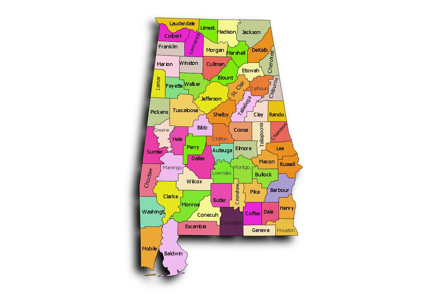
Political Map
The political map of Alabama illustrates the state’s administrative divisions, including counties, cities, and towns. Montgomery, located in the central part of the state, serves as the capital and the second-largest city in Alabama.
Major cities such as Birmingham, Huntsville, Mobile, and Tuscaloosa are prominent landmarks on the map, each contributing to the state’s cultural, economic, and political landscape.
Physical Map
The physical map of Alabama showcases the topographical features of the state, including mountains, rivers, and lakes. The Appalachian Mountains dominate the northeastern part of the state, while the Coastal Plain extends along the southern and western regions.
Natural attractions such as the Bankhead National Forest, the Sipsey Wilderness, and the Gulf Coast beaches are highlighted on the map, offering outdoor enthusiasts a myriad of recreational opportunities.
Tourist Map
The tourist map of Alabama highlights popular attractions, landmarks, and points of interest for visitors. From historic sites such as the USS Alabama Battleship Memorial Park to natural wonders like Noccalula Falls, the map provides valuable information for travelers planning their itineraries.
Cultural destinations, including the Alabama Shakespeare Festival, the Birmingham Civil Rights Institute, and the Huntsville Space Center, offer immersive experiences that showcase the state’s rich heritage and diverse cultural heritage.
History
Native American Heritage
Alabama has a rich Native American heritage, with indigenous tribes such as the Cherokee, Chickasaw, Choctaw, Creek, and Seminole once inhabiting the region. The Moundville Archaeological Site, located near Tuscaloosa, preserves the remnants of a pre-Columbian Native American civilization.
Civil War Era
Alabama played a significant role in the American Civil War, with battles such as the Battle of Mobile Bay and the Battle of Selma leaving lasting marks on the state’s history. The Confederate Memorial Park in Marbury commemorates Alabama’s Confederate heritage and honors those who fought in the war.
Civil Rights Movement
Alabama was a focal point of the Civil Rights Movement in the 1950s and 1960s, with events such as the Montgomery Bus Boycott and the Selma to Montgomery marches galvanizing support for racial equality. Landmarks like the Edmund Pettus Bridge and the Rosa Parks Museum pay tribute to the courage and resilience of those who fought for civil rights.
Economy
Agriculture
Agriculture is a vital sector of Alabama’s economy, with crops such as cotton, soybeans, peanuts, and poultry contributing significantly to the state’s agricultural output. Alabama ranks among the top producers of broiler chickens and catfish in the United States.
Manufacturing
Manufacturing plays a crucial role in Alabama’s economy, with industries such as automotive manufacturing, aerospace, and chemicals driving economic growth and employment opportunities. The state is home to major automotive assembly plants operated by companies like Mercedes-Benz, Honda, and Hyundai.

Tourism
Tourism is a growing sector of Alabama’s economy, drawing visitors from across the United States and around the world to experience its rich cultural heritage, outdoor recreational activities, and southern hospitality. The state’s Gulf Coast beaches, historic landmarks, and vibrant festivals attract millions of tourists each year.
Culture
Southern Hospitality
Alabama is renowned for its warm and welcoming hospitality, often referred to as “southern hospitality.” Visitors to the state can expect friendly smiles, gracious manners, and a genuine sense of camaraderie from the locals.
Culinary Traditions
Alabama’s culinary traditions reflect its diverse cultural heritage, with influences from Native American, African, European, and Asian cuisines. Signature dishes such as barbecue ribs, fried catfish, shrimp and grits, and pecan pie delight food enthusiasts with their savory flavors and hearty portions.
Music and Arts
Music and arts are integral parts of Alabama’s cultural identity, with contributions to various genres such as blues, jazz, country, and rock ‘n’ roll. The state is home to legendary musicians and artists, including Hank Williams, W.C. Handy, and the Muscle Shoals Sound Studio, which has produced hit records for artists like Aretha Franklin and the Rolling Stones.
Conclusion
Alabama, with its captivating landscapes, rich history, and vibrant culture, offers visitors a memorable journey through the heart of the South. From exploring historic sites and natural wonders to savoring southern cuisine and experiencing genuine hospitality, Alabama invites travelers to discover the essence of Dixie. By understanding the maps and facts of Alabama, visitors can embark on an immersive adventure that celebrates the state’s heritage and embraces its spirit of hospitality and charm.
What are 5 interesting facts about Alabama?
Alabama is home to the world’s first Mardi Gras celebration, which took place in Mobile in 1703.
The state’s official nut is the pecan, and it’s the only state in the United States to have an alcoholic beverage as its official drink, the Conecuh Ridge Whiskey.
Huntsville, Alabama, is known as the “Rocket City” for its contributions to the space program, including being the birthplace of NASA’s Saturn V rocket.
Birmingham, Alabama, has more than 1,000 acres of parkland within its city limits, earning it the nickname “The Magic City.”
Alabama’s Selma to Montgomery National Historic Trail commemorates the civil rights marches that helped lead to the passage of the Voting Rights Act of 1965.
What is a fact about Alabama geography?
Alabama is the only state in the United States to have all major natural resources needed to make iron and steel within its borders, including coal, limestone, and iron ore.
What is Alabama best known for?
Alabama is best known for its pivotal role in the American Civil Rights Movement, with iconic events such as the Montgomery Bus Boycott and the Selma to Montgomery marches taking place within its borders.
What states border the Alabama map?
Alabama is bordered by Tennessee to the north, Georgia to the east, Florida to the south, and Mississippi to the west.
Which state is very close to Alabama?
Mississippi is the state closest to Alabama, sharing a border along the western side of the state.
How many regions are in Alabama?
Alabama is typically divided into five geographic regions: the Appalachian Plateau, the Piedmont Plateau, the Ridge and Valley region, the Coastal Plain, and the Gulf Coastal Plain.
How many cities are in Alabama?
Alabama is home to numerous cities and towns, with over 460 incorporated municipalities throughout the state. Some of the largest cities include Birmingham, Huntsville, Mobile, Montgomery, and Tuscaloosa.
What is Alabama named after?
The name “Alabama” is believed to have originated from the Choctaw language, meaning “vegetation gatherer” or “thicket-clearer,” referring to the Native American tribes that inhabited the region.
How many mountains are in Alabama?
Alabama is home to several mountain ranges, including the southernmost extension of the Appalachian Mountains. While the state doesn’t have towering peaks like the Rockies, it does have scenic highlands such as the Cheaha Mountains, which are part of the Talladega Mountain range.
Who founded Alabama?
Alabama was not founded by a single individual but rather settled by various Native American tribes, European explorers, and settlers over centuries. The state was admitted to the Union as the 22nd state on December 14, 1819.

- The Most Dangerous Animals Of The Amazon Rainforest - September 9, 2024
- The Largest Empires In The History Of India - September 9, 2024
- The Largest And Smallest Canadian Provinces/Territories By Area - September 8, 2024