Iceland, known as the land of fire and ice, is a Nordic island country located in the North Atlantic Ocean. Renowned for its stunning landscapes, geothermal hot springs, and vibrant culture, Iceland is a captivating destination for travelers and explorers alike. In this comprehensive guide, we’ll delve into Iceland’s geography, explore its unique features, provide interesting facts, and showcase maps to help you navigate this enchanting land.
Introduction to Iceland
Iceland, with a population of approximately 360,000 people, is the most sparsely populated country in Europe. Despite its small size, Iceland boasts a rich history, vibrant culture, and breathtaking natural wonders that attract visitors from around the globe.
Fun Fact
Iceland is home to Europe’s largest glacier, Vatnajökull, covering an area of over 8,100 square kilometers (3,100 square miles).
Geography of Iceland
Iceland is a land of contrasts, with rugged coastlines, towering mountains, and vast volcanic plains. The country is situated on the Mid-Atlantic Ridge, where the Eurasian and North American tectonic plates meet, resulting in a landscape shaped by volcanic activity, geysers, and hot springs.
Fun Fact
Iceland is home to more than 130 active and inactive volcanoes, including Eyjafjallajökull, which gained international attention with its eruption in 2010.
Interesting Facts About Iceland
Iceland is known as the “Land of the Midnight Sun” due to its location near the Arctic Circle, where the sun remains visible for nearly 24 hours during the summer solstice.
The Icelandic language has remained relatively unchanged since the settlement of Iceland in the 9th century, making it one of the oldest spoken languages in Europe.
Iceland is home to numerous natural wonders, including the Blue Lagoon, a geothermal spa renowned for its mineral-rich waters and healing properties.
What are 5 interesting facts about Iceland?
Iceland is home to Europe’s largest glacier, Vatnajökull, and the world’s oldest parliament, the Alþingi. It’s also known for its geothermal hot springs, including the famous Blue Lagoon, and the Northern Lights, which are visible during the winter months. Iceland is one of the most volcanically active countries in the world, with more than 130 volcanic mountains scattered across the island.
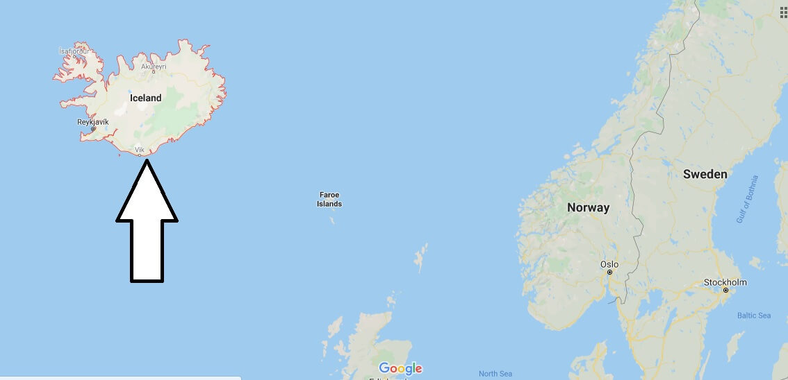
Where is Iceland situated on a map?
Iceland is situated in the North Atlantic Ocean, southeast of Greenland and northwest of the United Kingdom and Norway. It is located between latitudes 63° and 66°N and longitudes 25° and 13°W.
Where is Iceland known for?
Iceland is known for its stunning natural landscapes, including volcanoes, glaciers, geysers, and hot springs. It’s also renowned for its vibrant culture, literary heritage, and outdoor activities such as hiking, whale watching, and glacier trekking.
What is the full name of Iceland?
The full name of Iceland is the Republic of Iceland (Icelandic: Lýðveldið Ísland).
What is the nickname of Iceland?
Iceland is often referred to as the “Land of Fire and Ice” due to its combination of active volcanoes and glaciers.
What is the old name for Iceland?
The old name for Iceland is “Ísland,” which means “land of ice” in Icelandic.
What language is spoken in Iceland?
The official language of Iceland is Icelandic (Íslenska), which is a North Germanic language closely related to Old Norse.
What is Iceland’s national name?
Iceland’s national name is “Ísland,” which is the Icelandic word for Iceland.
Why is ice called Iceland?
Despite its name, Iceland is not covered in ice year-round. The name “Iceland” was chosen by the country’s early settlers to discourage further colonization and competition. Conversely, Greenland, with its icy landscapes, was named to attract settlers.
Where is Iceland from India?
Iceland is located thousands of kilometers northwest of India, in the North Atlantic Ocean. The distance between Iceland and India is approximately 7,000 kilometers (4,350 miles).

- Ecuador Maps & Facts - July 12, 2024
- Is England Part of Europe? - July 2, 2024
- Guatemala Maps & Facts - June 29, 2024