Introduction to The Bahamas
The Bahamas, located in the Atlantic Ocean southeast of Florida, USA, comprises over 700 islands and cays with rich biodiversity and a unique cultural heritage. This guide provides an in-depth exploration of The Bahamas’ geography, history, culture, economy, and notable features through maps and intriguing facts.
Geography of The Bahamas
The Bahamas is characterized by
- Archipelago: Consisting of 700 islands and over 2,000 cays spread across the Atlantic Ocean.
- Coral Reefs: Extensive coral reefs, including the third-largest barrier reef system in the world.
- Island Diversity: From the bustling capital of Nassau on New Providence to secluded, pristine islands like Exuma and Eleuthera.
Historical Insights
The history of The Bahamas includes
- Indigenous Peoples: Lucayan Indians inhabited the islands before European colonization.
- Colonial Era: Controlled by the British, who established plantations and brought enslaved Africans.
- Independence: Gained independence from the UK in 1973, becoming a sovereign nation within the Commonwealth.
Cultural Highlights
Bahamian culture is rich in
- Music and Dance: Junkanoo festivals featuring vibrant costumes and rhythmic music.
- Cuisine: Seafood delicacies like conch fritters, traditional dishes like peas ‘n’ rice, and tropical fruits.
- Art and Craft: Straw weaving, wood carving, and local artwork reflecting island life.
Economic Significance
The Bahamas’ economy thrives on
- Tourism: Major contributor to GDP, attracting millions of visitors annually to resorts, beaches, and water sports.
- Financial Services: Offshore banking and financial industries.
- Marine Resources: Fishing and aquaculture industries.
Notable Landmarks and Attractions
Key attractions include
- Nassau: Capital city with historic sites like Fort Charlotte and Government House.
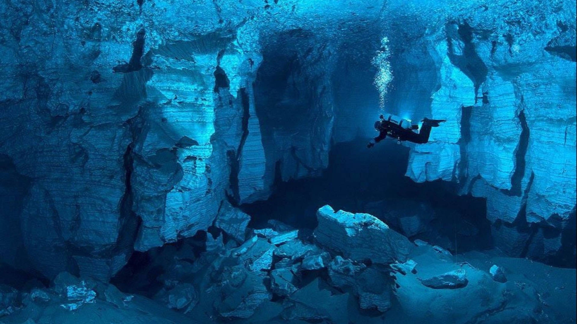
- Grand Bahama: Freeport, Lucayan National Park, and the underwater cave system.
- Exuma Cays: Swimming pigs at Big Major Cay, Thunderball Grotto, and pristine beaches.
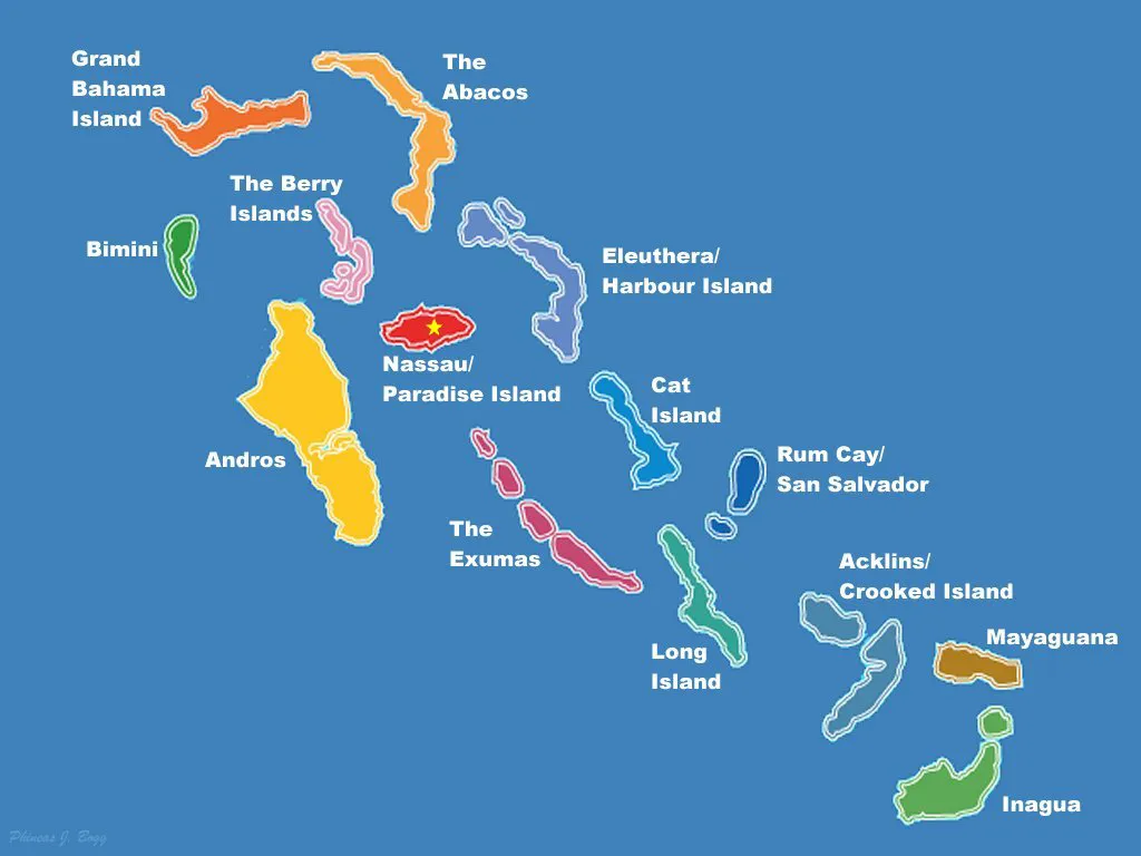
The Bahamas Maps
Explore The Bahamas through detailed maps showcasing
- Island Distribution: Main islands like New Providence, Grand Bahama, and the Out Islands.
- Geographical Features: Coral reefs, deep-sea trenches, and underwater caves.
- Transportation Networks: Airports, ports, and ferry routes connecting islands and mainland.
Fun Facts about The Bahamas
- Pink Sands: Harbour Island boasts beaches with pink sand due to crushed coral.
- Swimming Pigs: Exuma’s Big Major Cay is home to swimming pigs, a popular tourist attraction.
- Pirates of the Caribbean: The Bahamas’ history includes tales of piracy in the Golden Age of Piracy.
Travel and Tourism
The Bahamas attracts visitors with
- Luxury Resorts: Atlantis Paradise Island, Sandals, and Baha Mar.
- Water Activities: Snorkeling, diving, fishing, and sailing in crystal-clear waters.
- Nature Exploration: Birdwatching, hiking, and exploring natural caves and blue holes.
Environmental Conservation
The Bahamas emphasizes
- Marine Conservation: Protecting coral reefs, marine habitats, and endangered species.
- Sustainable Tourism: Balancing economic growth with environmental preservation.
- Climate Resilience: Addressing climate change impacts on coastal communities and ecosystems.
Conclusion
The Bahamas’ maps and facts unveil a captivating archipelago with diverse landscapes, vibrant culture, and economic vitality. As The Bahamas navigates global challenges and embraces sustainable development, its allure as a premier Caribbean destination remains steadfast. This guide serves as a comprehensive resource for exploring The Bahamas’ natural wonders, cultural treasures, and economic opportunities.
What are 5 interesting facts about the Bahamas?
The Bahamas is famous for its pristine beaches, crystal-clear waters, and vibrant marine life. It is the birthplace of the swimming pigs phenomenon, hosts one of the world’s largest underwater cave systems, has no income tax, and is known for its Junkanoo festival.
What is the country Bahamas known for?
The Bahamas is renowned for its stunning beaches, turquoise waters, luxury resorts, and vibrant marine life, making it a popular destination for tourists seeking sun, sea, and relaxation.
Where are the Bahamas located on the world map?
The Bahamas is located in the Atlantic Ocean, southeast of Florida, USA, and northeast of Cuba, in the region known as the Caribbean.
What country controls the Bahamas?
The Bahamas gained independence from the United Kingdom on July 10, 1973, and is now a sovereign nation within the Commonwealth, with its own government and constitution.
What is the nickname of The Bahamas?
The Bahamas is often referred to as the “Islands of the Bahamas” or simply “The Bahamas.”
How many islands are in The Bahamas?
The Bahamas comprises over 700 islands and more than 2,000 cays, ranging from large inhabited islands to small, uninhabited islets.
Who founded The Bahamas?
The Bahamas were originally inhabited by the Lucayan Indians. Christopher Columbus is credited with discovering the islands in 1492 during his first voyage to the New World.
What language is spoken in The Bahamas?
English is the official language of The Bahamas and is widely spoken throughout the islands.
Who owns The Bahamas?
The Bahamas is an independent country and not owned by any other nation. It is a member of the Commonwealth of Nations and has its own government and sovereignty.
Is The Bahamas a first world country?
The Bahamas is classified as a developing country with a high standard of living compared to many other nations in the Caribbean region. It is considered a stable democracy with a diversified economy focused on tourism and financial services.

- Hungary Maps & Facts - June 24, 2024
- The Bahamas Maps & Facts - June 13, 2024
- Colombia Maps & Facts - June 12, 2024